The OVLR Maple Syrup Rally Maps
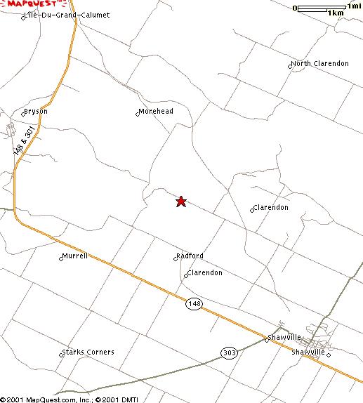
Shawville, Quebec
Getting there:
Aim for the red star...
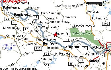
If you are unsure about directions, there will be a convoy of vehicles leaving from the Westgate shopping centre at 9am. (Northwest corner of Carling Avenue and Merivale)The following directions assume that you can find the Champlain Bridge at the north end of Island Park Drive in Ottawa.
- Crossing the Champlain Bridge over the Ottawa River, you will go straight to the second set of lights where the road ends at a "T". Go west (left). Follow the upper road (highway #148) through to Aylmer, past the Canadian Tire, to a set of lights at the park (there is a war memorial in the centre of the park to your right. The town library is across the street on your left) in the centre of town. Highway 148 does a right turn here at these lights. Follow Hightway 148 out of Aylmer and proceed to Shawville (you will pass by the villages of Luskville, Quyon etc.). Drive through/past Shawville. About one mile past Shawville, you will look for a side road on the right. The side road is marked with a small green sign that says "Radford" (there are a pair of barns across the road on the lefthand side of #148). Turn right onto Radford. Go straight, past the church, until the road ends. Turn right, then take the first left.
- You will take the first left at the next concession road. One mile from this turn, you will find Vern's farm on the left.
Other Information
PDF version of the 2000 page, but it has a map! |