Calabogie - Flower Station
Eastern Ontario, 1999
Background:
Time to revist an old set of trails that have been lying fallow for about four years, so dig out the topo maps and lets look for those squigly black lines. For those of you who are not familiar with Canadian topographic map the line in question refers to a 'cart track or winter road'. Sounds prefect to me. There are lots of them in the Calabogie area So off to Calabogie we go.The Event:Calabogie - Flower Station is a two day cross-country journey encompassing a hydro cut, and some serious abandoned logging roads and current ski-doo trails in the forests south of Calabogie. The total length of the trail we shall be driving is about forty kilometres. Under ideal conditions, you could do the entire trail in about nine hours, but ideal conditions never occur. The last visit, it took several hours to cross one stream.When:July 31st - August 1st. A revisit may occur later in the summer
Accomodations & Food What ever you bring, camping along the trail will be the flavor of the event. So, whether it be tent, inside your vehicle, it is whatever you are comfortable with Reservations/RSVP:Telephone or email Kevin Willey to say whether you will be coming along. Note: Because of the nature of this trip, and the problems associated with long convoys of vehicles, participation may be limited in the number of vehicles that attend. The club also reserves the right to turn away vehicles for mechanical or other associated reasons. If your vehicle is not fit for a fairly challenging off-road trip, it won't be going.Cost:This will depend on how much you spend on gas and food since we are not charging anything. The cost after will depend on how many parts you break and how bad you pound your body panels, if you care .Activities:
- A medium off road. This area has not been driven lately so you can expect anything. There is a lot of narrow trails, up along ridges through heavily wooded forest. Many trails are very rocky, from field stone to bedrock. There are some streams that require crossing and depending on the water table may require some winching.
- The run is rather technical. A similar trail for comparison would the the off-road course at the ABP rally in 1998 with the drive through the dry stream bed. Lots of that and more.
- Test your woodsmanship by clearing out windfallen trees
Getting There:We will be meeting at Girotti's gas bar and dinner at 8:00 on Saturday for breakfast (south side of Fallowfield at Moodie). We will then convoy to Calabogie where the fun will begin.To get to Girotti's. take the 416 exit for Fallowfield road and turn west. The diner is about an eight of a mile from the 416 at the corner of Fallowfield and Moodie Drive Maps:
-
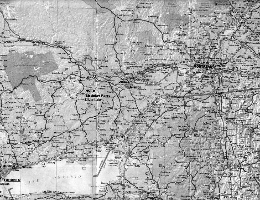
If you are curious, here is an image of a map of eastern Ontario / western Quebec and northern New York State. Calabogie is just a wee bit up and to the right of the "OVLR" marking the Birthday Party site. BPdirection.jpeg (270k) . Flower Station isn't on this particular map.
- The 1:50,000 map produced by Natural Resources Canada that covers the area where we will be going area is: CLYDE FORKS - 31 F/2. The map is in its fourth edition (1994). If you would like a copy, you can order one from World of Maps, 1235 Wellington Street, Ottawa, Ont. Canada. K1Y 3A3. Tel 1-800-214-8524. Fax 1-800-897-9969. Web is www.worldofmaps.com. Regular paper maps are $9.95 plus taxes and shipping. Tyvek maps are $10.70 plus taxes and shipping. Note: this map sheet does not have the town of Calabogie on it, that being on the RENFREW mapsheet 31 F/7 fourth edition (1985). Make sure you get the right map sheet.
|


